Translate

Showing posts with label буддизм. Show all posts

24 September 2009

Dedigama

The ancient Sinhalese chronicle, the Culavamasa tells us that the consort of Manabharana, the crown prince of Sri Lanka,

... bore a son at a moment marked by a lucky constellation. Clear at this moment were all the quarters of the heavens and cool, fragrant, gentle breezes blew. With the trumpeting of the elephants and the neighing of the horses the royal courtyard was filled with resounding din.

This heavenly event took place in a city known as Punkhagama, the capital of the principality of Dakkhinadesa, of which Manabharana was the sub-king (yuvaraja).

The child was named Parakramabahu (Parakkamabahu in Pali). Many years later, about 1153 AD he became king of the whole island as Parakramabahu I (the Great). He then constructed a shrine at the place of his birth, the Suthigara Cetiya (the Chaitya of the house of birth).

Interestingly, when Wilhelm Geiger (the father of Hans, the inventor of the Geiger Counter) was translating the Culawamsa, the location of Punkhagama had not yet been discovered. Geiger Snr tells us in a footnote that 'Parakkamabahu 1 erected a tope there 120 cubits high of which there ought still to be traces'.

Archaeological department board at the Kotavehera

This tope was identified later as the Kotavehera, in the modern village of Dedigama (pronounced tha-thee-gah-muh), and excavations were carried out there in the 1960s. So Punkhagama is most likely Dedigama. Apparently the place-name is derived from Jatigama, an alternative ancient name for the place.

The dagoba is the largest in the Wet Zone of Sri Lanka. Parakramabahu I was a great lover of monumental architecture and bigness generally. He made tanks in the Wet Zone (where they were not really necessary) in order to show off his prowess and in order to recreate the 'Milk Ocean' in a large-scale Mandala, a representation of the Indic Cosmos .

Obviously I am not a great fan of Parakramabahu's - his reputation was as much due to his panegyrist in the Culawamsa as anything he did; although it was possibly his unification of the Mahayana and Theravada Buddhist clergy in a single, state-controlled body which ensured for him a sympathetic press.

Sutighara cetiya from the north-east

Be that as it may, the dagoba is truly impressive. It is 78 metres (256 feet) in diameter and 14.3 metres (47 feet) high. I couldn't get the whole thing onto a single frame, so I had to do a stitch-up of two photos - a bit of a botch-up actually.

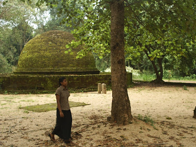
The size of the structure is illustrated by this photo of a senior citizen walking around it in the prescribed clock-wise manner. Note the multi-coloured branches of Na (Ironwood) trees in the foreground and the concentric perimeter rings (pesa walalu) at the base of the stupa.

Elderly man circling the dagoba

Not withstanding the size of the dagoba, it is referred to as the Kotavehera (short stupa) , not because of any deficiency in its height, but because it was built without the usual upper structure, the traditional cube-shaped enclosure (hatharæs kotuwa) and pinnacle (koth kærælla). Rather like calling a tall person short because they do not wear a hat.

On the eastern side of the dagoba, just above the second of the pesa walalu at the foot of the dagoba, is a smaller stupa, about 11 metres (36 feet) in diameter. It is said to mark the exact place of Parakramabahu's birth. It is that little pimple on the side of the dagoba, in my stitch-up shot above. The photo below shows it in close-up:

Smaller dagoba

The larger dagoba appears to have been anchored on the lesser. Here is an even closer shot:

Smaller dagoba

Excavations found a koraha (a pot for washing rice in) beneath the smaller dagoba. Not surprisingly, however, it was the larger which yielded the greater treasure. The main reliquary chamber, guarded by multi-headed cobras (like the one at Oorusitano tank), was complemented by 8 others arranged geometrically around it. The artefacts found there were housed in a museum built close by.

The way to the archaeological museum

A break-in occurred there not too many years ago, and the thieves got away with a large number of artefacts, especially some exquisite Buddha statues covered in gold foil. However, less monetarily valuable but priceless historically, the main prize of the collection was left behind. This was the elephant lamp.


Elephant lamp

This elegant oil lamp is one of a pair taken from the heart of the dagoba - the other being at the Colombo Museum. The identical lamps are of the hanging type and each consists an oil receptacle surmounted by an elephant and its mahout. The whole is suspended by the apex of a torana above the elephant, which is affixed to a chain.

Detailed drawing of elephant lamp

The elephant figure stands in the middle of the oil receptacle, which can be filled with oil. There is also a reservoir for the oil in the elephant's belly (marked in white on black in the central figure above). Oil is poured in using the hollow of one of the forelegs as a funnel.

After the lamp is lit, the level of oil in the receptacle goes down. When it goes below the level of the hole in the funnel-foreleg, an ingenious hydrostatic arrangement makes the pachyderm 'urinate' oil until the level of oil returns above the beast's feet. Obviously, the creator of this marvel of physics was something of a piss-artist.

Despite the burglary, many valuable artefacts remain in the museum, not just from Dedigama but from archaeological sites in the Kegalle area generally, including some interesting inscriptions. There is also a representation of the nine reliquary chambers of the Kotavehera, showing what was found where, and photographs of the dig.

You can get to Dedigama by turning to the right off the Colombo-Kandy road at Nelundeniya and driving about 3 kilometres (2 miles).


Dedigama is within easy driving distance of the rest houses at Ambepussa, Hanwella and Kitulgala, as well as the Ambalama hotel in Hanwella.

12 September 2009

Menikkadawara

In 2004 I was scouting out the terrain around the lower watershed of the Kelani river, when I (serendipitously) stumbled upon the village of Menikkadawara. To get there one has to drive up the Kandy road and turn left at Nelundeniya and drive for about 10 kilometres (6 miles) - not something a normal person would do too often without purpose. But there is a point to it.

Now a sleepy backwater, too unimportant to be marked on the map, Menikkadawara (pronounced man-ik-udder-were-r-er) was once a very important and strategic place situated in the foothills of the Four Korales (counties). The (not exactly accurate) mediaeval Sinhalese chronicle, the Rajavaliya tells us that two of the sons of the King of Ambulugala (Dharma Parakramabahu IX),
Prince Vijaya Bahu and Prince Raja Sinha built the city of Menikkadawara, and whilst young men, lived in one place and cohabited with one woman...

The first of these princes went on to become King Vijayabahu VII, while the second apparently died in Menikkadawara.

Menikkadawara marked with blue pin

During the latter part of the Portuguese era, the bulk of the colonial forces were encamped here. A rather long-winded Jesuit historian, Rev Fernaõ de Queyroz (Conquista temporal, e espiritual de Ceylao, translated by Father SG Perera, SJ) wrote in about 1688 that
... in the county Beligal, in the village of Manicrauare, 9 leagues from Columbo to the interior, we generally had our arrayal encampment, surrounded by very high mountains, in which one can hardly see an entrance or outlet, and because of its site and other conveniences it was the best that could be chosen, for it is 6 leagues from Candea and lies between the Four and Seven Corlas...

Just to prove that it was not just the English who mispronounced foreign names, the Portuguese called the place Manicravaré or Manicavarê. Queyroz informs us that
Mani-cauarê, and not Manicrauarê as they call it, means 'Come here my precious stone', words with which, they say, the Father or Rajú called to his son.

The Rajú referred to by Queyroz may be Raja Sinha, the second of the two princes with the racy lifestyle referred to in the Rajavaliya above, who died at Menikkadawara.

The embittered Captain Joaõ Ribeiro tells us in 1685 (Fatalidade historica da ilha de Ceilao, translated by PE Peiris) that:
In the Four Corlas, five leagues from Balane and eleven from Columbo, there was a position in the midst of the villages, known as Manicravare; here was stationed our chief army for opposing the King of Candia and for defending the Seven Corlas. It consisted of twelve companies of three hundred and fifty Portuguese Soldados under the command of the Captain Major of the field, and there were also a Sergeant-Major, two adjutants, a Captain of Munitions and a Franciscan monk as chaplain. It was further the residence of the Dissava, an officer corresponding to a military Governor of a province over the natives, who always had in hand three or four thousand Lascarins with their officers, which number could be greatly increased in the event of war.

In 1599 the Portuguese constructed a tranqueira, a wooden stockade. In 1626, this was upgraded. The rectangular fortification was known as the Forte Santa Fe and the Cidadela (Citadel) of Forte Cruz, with the four bastions on each corner being named Saõ Iago, Saõ Boa Ventura, Saõ Jorge and Saõ Pedro by the religion-obsessed Lusitanians.

On the right side of the road is a sign put up by the Department of Archaeology, indicating the fortifications of the Portuguese. HCP Bell, the first Archaeological Commissioner reported that a stone slab bearing the Royal Arms of Portugal was found here. However, all that is left of the fortifications are massive earthwork ramparts, grown over with grass and weeds.

Portuguese earthwork rampart

Ribeiro also mentions that Manicavare (sic) was not entitled to be called by the name fortress, since it was made of a little earth. However the ramparts look quite formidable enough.

Looking along the earthwork rampart (larger photo here)
After the defeat of the Portuguese in 1658, the area was re-occupied by the forces of the King of Kandy. The Lusitanian crusade had targeted Buddhist temples and the Monastery that now exists in the village was built after the re-occupation.

The sermon hall (Dharmasalawa) has had the interstices between the stone columns filled with cement breeze blocks - obviously recent. But how light and utilitarian the structure looks in comparison with the behemoths that are more modern Buddhist temples!

Sermon hall, Menikkadawara Purana Vihara (larger photo here)

The brown strip at the bottom of the outer wall is caused by back-splash from rain pouring off the roof (notice the absence of roof gutters). As you can imagine, rain is quite a factor in the valley of the river Kelani. Queyroz informs us that
... though it rains in the island of Ceylon almost the whole year and sometimes for eight and ten days running, when the rain ceases there is no mud seen in that place because of a kind of stony soil and because the barracks (estancas) are on a height whence the water drains easily making for the fields which surround it.
Evidently it was the consideration of floods which caused the image house of the monastery to be built on a wooden platform mounted on short stone stilts. A temple building built in this architectural form is referred to as a tampita vihara. This one appears originally to have been built with an open verandah all round, which has been filled in with brick.

Image house (buduge), Menikkadawara Purana Vihara (larger photo here)

The image house is illustrated with frescoes of the Buddha and of the Cula Dhammapala Jataka. These probably date from the 18th or 19th centuries.
Image house door and doorway fresco

The ceiling has a beautiful floral design, marred somewhat by the 1930s-style electrical light fittings:

Image house ceiling design
Menikkadawara can be taken in while en route to Kandy from Colombo. Alternatively, for those who want to explore the whole area, there is a rest house at Ambepussa which provides accomodation. Also within easy driving distance of the rest houses at Hanwella and Kitulgala, and the Ambalama hotel in Hanwella.

19 August 2009

Pattini Devale, Panama

After the 2004 Boxing Day Tsunami, I made several trips to Pottuvil on the East Coast of Sri Lanka with loads of supplies for the displaced people. On one such trip, in early April, I continued south to the village of Panama (pronounced paa-nuh-muh).


Over 200 years ago, on the 13th of September 1800, an Englishman, William Orr, Esq (a civil servant) visited Panama on the way from Tangalle in the south to Batticaloa in the East. According to his report to the British Governor,
Paoneme contains sixty inhabitants, who cultivate seventy-three amonams of paddy ground.

The following year Thomas Anthony Reeder, surgeon of the 51st Regiment of Foot (who was to die soon after, during the 1st Kandyan War) travelled in the opposite direction. According to his journal,
Panoa is situate on a plain surrounded by jungle. Here are some cultivated fields, and several large stocks of paddee.


A year later, the British Governor himself, the Hon. Frederick North (later 5th Earl of Guilford), followed the southward route. He was accompanied by the Inspector of Hospitals in Ceylon, Thomas Christie, Esq, who reported that
Panoa is a considerable village, and the country round it abounds with paddee fields.

What these descriptions - which appear in James Cordiner's A Description of Ceylon (London, 1807; Dehiwela, Tisara Prakasakayo, 1983) - show (apart from the recognised inability of the English to tackle with any accuracy the phonetics of foreign place names) is that Panama's chief attraction was its paddy fields. The surrounding jungle was far more notable to these perfidious Albionians: Christie was highly excited by the sight, en-route to the village of
a herd of wild hogs, and an alligator, both of which allowed us to approach very near.


Rock, fields and tank at Panama

When I visited the place, however, it was in the knowledge that it possesses a Devale (temple) of the goddess Pattini. The shrine, on a rocky spot on the shore of a tank, is a Buddhist one. However, Hindu shrines of Pattini also exist, although she was not originally a Hindu deity.


Main Pattini shrine (larger photo available here)

Pattini is a goddess of fertility, who may originally have been a middle-eastern deity, Potnia. Mogg Morgan calls Pattini one of the many names of Isis, pointing out that in both cases the male consort is killed and dismembered, but brought back to life by the female deity.

Pattini was said to have been born from a mango and to have destroyed the city of Madurai by tearing off her breast and casting it on the ground, a sort of divine nuclear hand-grenade.


Image of Pattini in the shrine. The doorway to her right leads to the inner sanctum

Pattini was married to Palanga, a mythical ancient South-Indian version of Prince Philip. Palanga appears to have done little except hang around being dissolute with a pretty young mistress and get himself killed by a wicked king. Nevertheless he is propriated as 'Alut Deviyo' ('the New God'), having his own shrine next to his more powerful wife's.


Palanga's shrine (larger photo available here)

Originally Pattini and her consort did not have elaborate temples to house them, the present structures having been built in the 1920s. Instead, two large tamarind trees served as shrines.

Tamarind tree (original Pattini shrine)

In addition to the two large temples, two smaller shrines have been built to the Parakasa Deviyo, the guardian deities of the temple precinct - who punish those who misbehave on the premises.
Shrine of one of the two guardian deities (Parakasa Deviyo) (larger image available here)

One of the central rituals of the Pattini cult is the Ankeliya, the Horn Game, which is similar in concept to the town games of Uppies and Downies in Britain - including it being a male-only sport. In the Ankeliya, two opposing teams, the Udupila ('Upper team') and the Yatipila ('Lower team') try to break the horn of the opposing team in a game of tug-of-war.


Horn tree and channel for the 'thunderbolt tree' (another, larger photo of the Horn Tree available here)

The Upper team tie their horn to the 'horn tree', which grows about equidistant from and slightly behind the shrines of Pattini and Palanga. The Lower team tie their horn to a large tree trunk about 4.5 m (15 ft) long, pivoted in a 2 metre (6 ft) long channel and held in position by logs called 'haepini kandan' ('female cobra trunks'). This tree trunk is called a 'Thunderbolt Tree' (henakanda - cf Anaconda). Paranthetically, these Milliganesque references to snakes in what is, after all a fertility ritual should make a psychoanalyst positively drool.


Closer view of the channel for the 'thunderbolt tree'

The two horns are hooked together and two ropes are tied to the 'thunderbolt tree'. The two teams tug on the ropes, moving the the 'thunderbolt tree' forward and bringing tension to bear on the two interlocked horns until one of them snaps. The winning team - the one whose horn doesn't break - gets to yell obscene songs at the vanquished team; certainly worth more than a cash prize.

To see some photos of the ritual, go HERE.

If you want to visit Panama, it is quite close to the lovely Arugam Bay, which has a few hotels. If you want to learn more about Pattini, you can go to this website or read Gananath Obeyesekere's excellent anthropological study, The Cult of the Goddess Pattini (Chicago: The University of Chicago Press, 1984; ISBN 0-226-61602-9). And here is an interesting take on Pattini in the context of modern Western society.

11 August 2009

Yudanganawa

Near the town of Buttala in the Moneragala district, is Yudanganawa, an ancient monastery dating back to the 2nd century BC.
Map: Yudanganawa marked in yellow

I went there in early 2005, on the way back from Tsunami relief work in Pottuvil on the East Coast. At the entrance to the complex of Yudanganawa (which means 'woman of battle' or 'beauty of battle') stands the small dagoba of Chulangani or Chulanganawa ('small woman').
Chulangani stupa

Chulanganawa was the site of a battle between King Dutugemunu (Duttha Gamini Abhaya) and his younger brother Tissa (Tisa):

And between those two there came to pass a great battle in Culanganiyapitthi: fell many thousands of the king's men. (Mahawamsa, ch. xxiv)

Tissa not only defeated his older brother, he also captured the king's war-elephant, Kandula. Dutugemunu didn't re-capture his beloved pachyderm until much later. Kandula was the most celebrated elephant in Sri Lanka's history, later being used to batter down the wrought-iron gate of a fortress:

Roaring like thunder he came, daring danger, and with his tusks pierced the panels of the gate and trampled the threshold with his feet; and with uproar the gate crashed to the ground together with the arches of the gate. (Mahawamsa, ch xxv)

As an aside it might be mentioned that, in the 21st century, Kandula's monicker was bestowed on the first male elephant to be born to the Smithsonian zoo by articifial insemination - itself the child of a first-generation Sri Lankan immigrant to the USA.

Amazingly, after his eventual victory, the king commemorated his defeat in this battle by building the Yudanganawa monastery here. It is not often that one hears of a monarch celebrating his setbacks, especially a defeat as humiliating as this one!

Close by the dagoba is the image house or buduge (literally 'Buddha House'). Only the foundation, the pillars and part of the altar remain.
Image house ('buduge') at Chulanganawa

The approach to the main dagoba at Yudanaganawa reveals its impressive size. It is not as tall as the three large dagobas at Anuradhapura, but it is much broader at the base. Unfortunately the site is heavily forested, so I found it difficult to take a good photograph of the dagoba itself.

Yudanaganawa: main dagoba and image house

I first visited the image house. This is a mediaeval structure, possibly built on foundations similar to those of the Chulangani image house. Inside, it is illustrated in a typical mediaeval manner, with statues of deities and frescos and bas-reliefs on the walls.

The gateway to the inner sanctum is guarded by two painted bas-relief lions rampant. Sri Lanka has not had native lions for many centuries, and the artist was not familiar with what was almost a mythic beast. Hence, the lions looked more like large mastiffs. However they look frightening enough, so their purpose of inspiring awe in the beholder was probably served.

Doorway to inner sanctum of image house

The inner sanctum was very dark and I could just about get photographs of the frescos and statues on my cheapish camera. The art was very mediaeval - a regression from the artistic wonders of the 1st millenium - and, in comparison with the ancient structures visible outside, was not very impressive. That may have been why they installed the two fierce looking guardian lions - to strike terror in the souls of scoffing art critics.

Inner sanctum

The Archaeological Department has been carrying out excavation and conservation work at Yudanganawa for years, and it should continue for at least two decades more. When I went there the scaffolding, which had been erected to help with the archaeological work, was much apparent on the sides of the main dagoba.
Yudanganawa dagoba - note scaffolding for conservation work

The dagoba is quite different in style from conventional stupas - unlike them, it is built in two 'stages', with a smaller dagoba surmounting the massive main structure. It is rather as if the builder had sliced off the middle layer and laid the apex directly onto the base (as is apparent in the photographs below).

Noting that there was nobody around, your doughty correspondent decided to scale the scaffolding and (illicitly and with malice aforethought) climb up on top of the massive dagoba.

The view from the top

The view from the top was quite impressive. It was also good to be able to see, close-up, the consevation work going on right on top of the dagoba. It was quite obvious why this work was necessary - there were trees growing on top of the structure!
Conservation work on top

It was possible to see the hundreds of thousands of bricks of which the dagoba is composed. I wish one could say that the dagoba is made entirely of brick, but I am informed that this is not so: apparently the building contractors of yore were as shifty as their modern counterparts, and many dagobas have cores of clay.
The small stupa on top of the massive base